Delivering accurate, reliable, and actionable geospatial data to support informed decision-making and successful project outcomes.
0
+
We provide structured, reliable solutions that help organizations plan, operate, and make decisions with confidence. By combining modern systems, analytical insight, and proven methodologies, we support efficiency, accuracy, and long-term performance.
We deliver dependable services designed to support smarter planning and informed decision-making. Our approach integrates advanced tools with practical expertise to ensure accuracy, consistency, and timely outcomes across every engagement.
Call us anytime
(303) 862-8801
Delivering accurate, reliable, and actionable geospatial data to support informed decision-making and successful project outcomes.
Delivers precise data to define property boundaries and ensure clear land ownership.
Accurate elevation data and terrain details for smarter planning and development decisions
Provides expert guidance to leverage spatial data for informed decision-making and efficient project planning.
Choosing the right partner means ensuring accuracy, consistency, and informed outcomes. We apply structured methodologies, proven expertise, and modern systems to deliver dependable results that support confident decision-making.
We provide structured data solutions to support informed decision-making and successful project outcomes.
See how our reliable data solutions and expert analysis have supported smarter planning, streamlined operations, and successful outcomes across a variety of client projects.
We conducted a full boundary and topographic survey for a 60-lot residential development. The data supported precise site planning, grading, and infrastructure layout, helping the developer save time and avoid costly revisions.
Our team provided construction staking and alignment verification for a 12 km highway expansion project. Using GNSS and total station equipment, we ensured accurate placement of road features and minimized field errors during construction.
We delivered detailed topographic and utility mapping for a major shopping complex development. Our high-resolution data was essential for drainage planning, foundation design, and construction permits.
Our clients trust SDS to provide accurate, actionable geospatial data and insights that support informed decision-making and successful project outcomes.
"Their attention to detail and quality control ensured that our project stayed on track. Reliable data, delivered on time."
Property Developer
"We needed accurate mapping and quick turnaround. SDS delivered exactly what we needed—professional, responsive, and dependable."
Civil Engineer
"Working with SDS gave us clear, actionable data. Their insights and timely support made project planning smooth and efficient."
Architect
"The mapping and analysis were precise and well-structured. Their services helped us avoid design errors and make confident decisions."
Reliable data is the foundation of every successful project. Partner with a team you can trust for precise, efficient, and expert data solutions.
SDS delivers data-driven solutions including topographic mapping, digital orthophotography, GIS consulting, LiDAR processing, utility mapping, flood zone mapping, and project management support.
We combine advanced technology, structured workflows, and rigorous quality assurance processes to provide reliable and precise data for decision-making.
Yes. Our team has the expertise, technology, and project management experience to handle projects of any scale, delivering consistent and timely results.
We provide fast and efficient data delivery through streamlined processes and secure digital platforms, ensuring you have the information you need when you need it.
Absolutely. Our services are designed to produce compliant, verifiable data that meets industry standards and supports planning, development, and operational decisions.
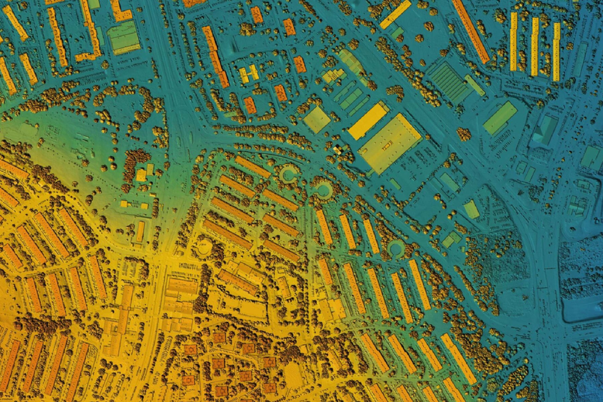
Introduction:Modern projects demand precise spatial data to inform planning, monitoring, and operational efficiency. LiDAR and remote sensing provide unparalleled detail for diverse applications. Body: LiDAR...
Introduction:High-quality data is only valuable if it’s reliable. SDS prioritizes rigorous quality assurance to ensure every dataset and map meets the highest standards. Body: Rigorous...
Introduction:In today’s fast-paced world, reliable data is the foundation of every successful project. Spatial Data Solutions (SDS) helps organizations leverage geospatial information to make informed,...
Michael R.
Project Manager